Total Pageviews

Wednesday, July 25, 2012

Figure 8 on a stick

There are a cluster of trails in the southeastern part of the Northern district of the Shenandoahs that lend themselves to a wide range of circuit hikes.  On July 24 I hiked two conjoined circuits by rehiking one mile of the Piney Ridge Trail.  In keeping with my hot weather strategy I got on the trail early and out in early afternoon.  After parking (only by reading the Shenandoah Trail Guide could I have figured out where to park), I hiked up the Piney Branch Trail, noting deep pools in the inviting stream for my return trip.  Note that there is no blazing where the trail winds its way through vacation homes ... you just take the obvious road. 

The vestigial stone walls reminded me that I was walking in what had once been a farming community.


Turning onto the Piney Ridge Trail, I ascended on a lovely, well-graded trail to the ridge.  No views, but it was breezy and seemed drier than the tropical forest in the stream valley.  More evidence that it will be an early fall.


After the junction with the Fork Mt. Trail, the pitch leveled out and I had a pleasant walk by many ripe blackberries and raspberries to PATC's Range View Cabin.  It was too early for lunch so I just sat down for a drink and to watch the myriad butterflies in the meadow.


Then I hiked a short distance along the A.T. until I met the Piney Branch Trail again.  I walked up to the Piney Branch Maintenance area and back (just to complete the trail) and then descended along the delightful Piney Branch Trail.

In addition to neat rocks, there were many waterfalls and cascades once I rejoined the actual Piney Branch.  It was impossible to take pictures of the cascades.  You have to go see them.  Lots of nice pools for dipping too.


At around 1 PM I started to hear thunder, just as I was reaching the junction with the Piney Ridge Trail for the second time.  I didn't see any lightening, there was no wind, and there were long periods between rumbles, so I decided to complete my intended journey for the day.  I reascended the Piney Ridge Trail and took the Fork Mountain Trail down to the Hull School Trail at a very fast trot.  By this time it was rainy lightly but steadily.  Then I sped down that little section of the Hull School Trail that connected back to the Piney Branch Trail.  I retraced my steps to the car along the Piney Branch trail, stopping briefly to dunk my head.  Since it was raining I didn't think it made sense to take a full body dip.  I was back to the car just after 2:30.

I constantly have to revise the excel table with trails.  I discovered on this trip, for instance, that the list double counted 0.2 miles of overlap between the Hull School Trail and the Piney Branch Trail.  

Mileage for the day (including side trips):  15.3
New trails:  3 (plus a new section of the Hull School Tr.)
New miles on new trails:  11.6
Total completed side trails to date:  77
Total miles on side trails to date:  192.6

Number of side trailSide trail miles

Tuesday, July 17, 2012

Bears and Trail maintainers in North District

Today started out great!  I parked at the parking lot just off SR 614.  As I started up the Little Devils Stairs trail I heard a commotion off to my left.  About 50 feet away a large bear was taking off.  But then I saw one ... two ... three little cubs too.  One cub climbed up a tree so the mama came back.  She looked at me meaningfully and I backed up the trail a ways to give her space.  The little guy climbed down and they all scampered off.  The Little Devils Stairs trail is a delight.  Literally climbing up stairs (some created by PATC) beside a boisterous brook, it was a multisensory walk complete with flowers, butterflies, and neat cliffs.   

Stairs on Little Devil's Stairs


Because it was supposed to be a scorcher today, I got an early start.  It was still hot and muggy but in the shade the temperature was tolerable and a nice breeze cooled me off.


I should have gone in for a dip but I thought I'd have a chance on my way back downhill later in the day. Little did I know that the "Keyser run fire road" did not go near any "Keyser Run" stream. 

When I reached the junction with the Keyser Run Fire Road I was surprised and delighted to meet Peter and Maritza, the two trail maintainers for the trail I had just completed.

They were prepared for the worst (with a big two person saw) but when I told them the trail was completely clear they left it at the trail junction to recover later.  They clearly take their job seriously.  The trail was in excellent condition.  Thanks Peter and Maritza!

I then walked up the Keyser Run Fire Road, got onto the AT and found a great overlook soon thereafter.

I walked along the AT until the next road crossing where I took the Sugarloaf Trail.  That trail exemplifies many trails in the park:  nice moss alongside the trail and mountain laurels overhead.  Before I knew it I had reached the Pole Bridge Link Trail.  I walked over to the Piney Branch Trail and back then continued on to rejoin the Keyser Run Fire Trail again.  the PBLT is a fairly level trail that's useful when you want to do a circuit hike.  After rejoining the Keyser Run FT again, I descended.  Soon I saw something flash across the road.  At first I thought it might be a fox because it was low and quiet.  But then when I passed by where it had gone into the woods, I heard the familier crashing of a bear and sure enough saw its rump as it hightailed it into the woods.  Then just beyond that I heard yet another bear in the woods.  I guess it was my day for bears.  No photos of these shy creatures, unfortunately.  After an amazingly quick walk, I met up with the Hull School Trail, just after a graveyard where a tree had fallen over in the recent freaky weather.

I followed the Hull School Trail downhill to the Rocky Branch Trail hoping fervently that I would encounter the Rocky Branch (and hopefully a little pool) at the trail junction.  No such luck.  All I found were a bunch of downed trees along the path.  So I retraced my steps along the Hull School Trail (all uphill in the heat of the day) back to the Keyser Run Fire Road and hightailed it back to my car.

The Keyser Run Fire Road is the kind of Fire Road I think we should keep in the SNAP 500:  It's not a road road but nonetheless gets enough use or maintenance to provide clear tracks for walking.  AND it connects trails to facilitate circuit hikes.  As intended I was off the trail by 2 PM, just as the maximum heat built up.

As some neat fungi today and evidence that the drought is changing the leaves early


Mileage for day: 11.9 (or maybe 13.3).  New side trail miles:  9.3.  New side trails:  4.

Side Trail Miles


Side Trail Number
Miles as percent total miles (including AT):  35.4 (more than 1/3 there!)
Total Miles Hiked:  206

Saturday, July 14, 2012

Reader poll: what trails to include

I'm in a crisis of conscience now.  I started out by saying that I would hike all the trails in Shenandoah National Park.  The Park claims there are more than 500 miles of trails.  I assume this figure has been calculated based on the mileage recorded for all trails listed on the back of the PATC maps.  I feel that the Park has actually exaggerated the hiking trail mileage.  The problem is that some of these "trails" aren't trails but really roads ... those "well maintained" fire roads, for instance.  For some "trails" on the maps, the book states that they aren't meant to be hiking trails (see "Gasline Road" in the Southern section). 

I decided on Thursday that I wasn't going to hike the fire roads unless they connected trails because they are either real roads or they are disastrously overgrown roads.  If they were trails maintained by the PATC they'd be in good shape.  But fire roads aren't maintained by PATC and it shows. 

After I got home, Artunus gave me grief because I was not holding true to my original commitment to hike all 500 miles of trails.  I also remember way back when the Mt. Marshall Trail used to be a fire road and it was a great trail.  So maybe I shouldn't dismiss all the fire roads.  Maybe just the road roads that don't connect trails (like the Tanner Ridge Administrative Rd.).  Why doesn't SNP help me out by maintaining its fire roads or abandoning them altogether. 

OK readers.  Here's your chance to weigh in.  Please vote for one of the following.  Should I a) hike all the trails originally listed (which includes trails plus fire roads of all kinds plus the Gasline Rd.), b) hike all the real "trails" plus only the "fire roads" that connect trails c) hike all the "trails" plus all the "fire roads" except those that are basically roads (except where the "roads" connect trails) or d) hike all the real trails and skip the fire roads?  I'm waiting to hear from you. 

Central District 3 days of hiking


July 10, 2012

Got a late start because I stopped by the Walmart in Ruckersville to get an access permit for the Rapidan Wildlife Management Area.  I may never need it but at least I can’t be fined. 

Hiked up and back on all trails today.  Started with the Entry Run Trail (2.4 mi.by guidebook; 2.5 by mileposts).  What an excellent trail … well built, well-maintained!   

Here are some terrific rock steps in the trail


It climbs up fairly steeply, but with many switchbacks, to the Pocosin Fire Road.  Almost half way up is an old cemetary with some stones completely unmarked and others in quite good shape.


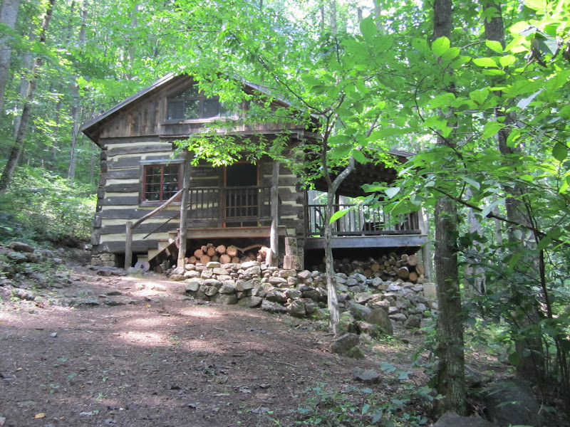
En route I stopped at the wonderful Rosser-Lamb Cabin which looks terrific. 

It was surrounded by huge black swallowtail butterflies. 

  The Pocosin Fire Road is in lousy shape (above).  I’m not sure what gives with these “fire roads” but the Pocosin Fire Rd. is not in any condition to serve as an emergency access or as a hiking path.  It has high weeds and branches/trees across the roadbed.  It looked to be much clearer beyond the gate at the Park boundary.  I walked down to the gate on the east (0.7 mi. by the guidebook; 0.6 by the milepost) then retraced my steps and continued on to the Pocosin Hollow Trail (0.5 mi) to the Pocosin Trail (aka Pocosin Horse Trail) (0.2 mi. further).  At the junction was a dilapidated house and the foundation, chimney and stairs to another house.  I wonder what is the story.   


Continuing on the Pocosin Trail I first descended, crossed some water courses, then ascended to the South River Fire Road. (1.5 or 1.6 mi.to Fire Rd.), another dysfunctional fire road, at least until the junction with the S. River Falls loop trail (1.1 miles).  Weeds grew all over the place and I was concerned about ticks in the long grass.  As a sweet surprise, I was able to pick some early blackberries and many raspberries.  YUM!   


I walked as far as the junction with the South River Falls loop passing some late columbines


then I retraced my steps to the base of the Entry Run Trail.  The only people I saw were two people coming up the S. River Falls trail and one guy coming up the S. River FR while I walked down.  Back on the Pocosin Fire Road between Pocosin Hollow and Entry Run Trails I saw a young bear, who took off like a streak of lightening when he saw me.  Because I got to the Entry Run trailhead a little early, I decided to stroll up to John’s Rest, another PATC rental cabin (also, because I heard flowing water).  John’s Rest is a wonderful little cabin 


and right by the cabin someone had dammed up the stream and made a nice pool so I took a dip.  Heavenly!  I hadn’t been that hot (certainly not as hot as last week) but the dip felt superb.  


After my dip, I hightailed it up to the Park because Artunus and I planned to stay at Skyland.  Due to my membership in the Shenandoah Park Trust I got 50% off on the room rate (plus 20% of meals from Shenandoah National Park Association membership)!  Those memberships paid for themselves many times over.  The first thing I noticed in Skyland was the exquisite smell of the milkweeds.  Overpowering!  Before dinner, we took the trail to Bushy Head and Miller’s Head (1.6 mi. RT).  What a spectacular view from Miller’s Head!  I I I hadn’t even heard of it before.   

Saw some great butterflies that day


We had a great time at Skyland.  Saw an adolescent bear sauntering through the parking lot on the way to dinner.

Total mileage for day:   14.4 miles; 7.2 miles new side trails; 2 complete new side trails and 2 partials. 

Wednesday, July 11.  Artunus departed for his job and I decided to tackle a couple more fire roads.  I am baffled by this term “fire road”.  Some of them are clearly ready to be used in case of emergency and others are completely neglected.  The first fire trail, Red Gate, was cleared and obviously well-used.  Once US gov’t vehicle passed me while I was descending.  Although I’m not wild about fire roads, this one was a breeze to walk along and I managed to hike the 9.6 miles (RT) in 2 ½ hours.  Then, after a short trip to Big Meadows for a NPS Passport Stamp and some refreshments, I continued back to Skyland.  First I hiked the Nature Trail aka Stony Man Trail aka Appalachian Trail, repeating a leg so that I could also hike the Stony Man Horse Trail (1.9 miles total).  An excellent Nature Trail guide is available at the start of the NT.  Then I hiked down the Furnace Spring Trail (0.5 mi.) to the Skyland Fire Road (referred to erroneously in the Furnace Spring trail description as the Old Skyland Road Trail).   The Skyland Fire Road is one of those in a diisused and overgrown state.  In fact this one was so overgrown and unpleasant that it took me more time to hike 6.4 miles on it than it took me to hike the 9.6 on the Red Gate Fire Road.  Aside from a few foxgloves along the way, the trail was not noteworthy.   


It’s a shame that, given its historical role in Skyland (it was used, apparently, to carry early visitors up to the Skyland Resort), the Skyland Fire Road is not maintained and there are no educational signs.  The bottom third of the trail was virtually weed free but the top was bad. After getting back to Skyland I walked back to my car on the road.

Total miles for the day:  18.9 of which 9.5 new side trail miles.  5 new trails.  Note to file:  I need to reduce the number of trails (and possibly trail miles) in the inventory due to the overlap of trails with two and sometimes three names for the very same trail.  

On Thursday, July 12 I started out with good intentions.  Having eliminated the White Oak Canyon Fire Road from my list (because it is overlapping with the Skyland-Big Meadows Horse Trail which I will hike at a future point), I started out the day with the "Story of the Forest Trail" in Big Meadows (of which only a small portion is actually trail, the rest being the sidewalk from the Big Meadows Lodge down to the Wayside) and then I connected to the Lewis Falls Trail.  As I approached the Falls, I spotted yet another bear who dashed away as soon as it heard me.  The falls looked quite good.


Down below the falls the death and destruction caused by the wooly adelgid was obvious


After getting off the Lewis Falls trail I had intended to hike the Tanner Ridge Administrative Road but as I passed the gate and noticed a 20 mph speed limit sign I lost heart.  I just couldn't bring myself to walk on a regular road even though it is listed on the map as a trail.  So I walked down the road as far as the Tanner Ridge Horse Trail and followed it back to Big Meadows passing thistles along the way.  


Then I walked up and back on the sidewalk to complete the route of the Story of the Forest Trail described in the book and returned to my car (4.5 miles total).  

Then I proceeded to the South River Falls Loop, stopping en route to walk the last missing bit of the Pocosin Fire Road (between the parking lot and the AT).  Although there were a number of cars in the S. River Picnic area, after passing one group of visitors on the way to the falls, I saw no one else the entire time.  The falls are beautiful.


I did take the trail all the way to the bottom of the falls and was rewarded with a refreshing dip in the pool there.  Even though I was soaking wet, the walk back up the hill was hot.  Instead of taking the official loop, I continued on up the S. River Fire Road (thereby completing it) and crossed over to what sounded like a neat trail ... the Dry Run Falls Fire Road.  Feh!  Another unmaintained fire road.  I started down the fire road hoping it wouldn't be too bad but eventually it deteriorated in swathes of high weeds.  At that point I was fed up with overgrown fire roads and returned to the car.  Total 4.9 for that bit of walking.  Then (hope springs eternal), I went to the Meadow School Trail and hiked that out and back.  It had been maintained but still had a bunch of vegetation on it.   Some day I hope to rehike it as part of a circuit with the Powell Mt. Trail but the latter is currently inaccesible from Skyline Drive due to construction on the Hazeltop Ridge Overlook.
Total for Thursday:  12.4 miles; of which 10.9 unique new trail and 7 new trails completed.

Side Trail MilesSide Trail Number

Saturday, July 7, 2012

Slaughter Rd/Pocosin Hollow circuit

On July 5 I returned the the SNAP 500 after a long hiatus.  It was not a great day.  I couldn't find the road at the bottom (map reading failure) so I belatedly made my way into the Park and started up on the ridge.  I hate doing trails that way because I end up going uphill in the heat of the day.  I started down the Slaughter Road. late (10:30) and was quite disappointed to see it filled with long grass, prime territory for deer ticks.  But I did catch sight of a cute box turtle.

Also some Indian Pipes coming out.

After the trail left the park (or at least the signs would indicate so), the road cleared out but I still found a regular tick crawling up my leg.  By the time I reached the Conway River (3.8 miles according to the milepost), I was hot so I hopped in for a quick dip.  Then I walked the final 0.3 miles (according to the milepost) to the road.  I had a great deal of trouble finding the Pocosin Hollow Trail, in part because I got confusing directions from a local man.  If I had just stuck with my map I would have been ok.  Instead I walked up and down the road (VA667) in the broiling sun for about an hour.  Finally, after walking up private roads with occasional signs, I found the trail and the SNP again.  I stopped for lunch but wasn't hungry, just overheated.  Shortly thereafter the trail crossed the stream and I took another dip.  If felt absolutely wonderful.  In about my fifth stupid mistake of the day, I lost my glasses while transferring my pack (upon which they rested) from the stinging nettle patch to a rock.  After 1/2 hour of searching with myopic eyes I gave up and packed up to leave.  Luckily I caught sight of them wedged between the rock and the stream just at the last moment.  Even better, by the time I finally started hiking again, I was totally cooled down.  The hike up the Pocosin Hollow Trail was lovely, with the brook burbling next to me.  I took another opportunity to submerge my head underwater.  Met a youth group out with backpacks along the way.  I stopped briefly at the Pocosin Cabin to have a snack (still not hungry) and a drink.  Then rapidly continued back to the car along the AT.  Just north of Lewis Mt. Campground I saw a large black lump in the middle of the trail.  It was a bear!  It didn't really seem to want to move (who would in the 90 degree heat?) but I got my camera out and got it's picture just as it got to a standing position.  When the auto flash went off, it raced away crashing through the woods.  In fact, I think there might have been a second bear too, given the noises. 
Although only around 13 miles (according to guidebook) or maybe 11.8 (3.8 Slaughter + 0.3 Conway R. + 0.3 road + 4.6 Pocosin Hollow & Fire Road + 2.8 AT), given the heat and the late hour I started that was more than enough.  This trip was a good opportunity to remember what I need to bring on my outings (because I forgot them) and also to shake me up about map reading.  It also suggests to me that I need to delay walking on the "road" trails until it's cooler.  In my experience "roads" have very high grass and are likely to have ticks so I need to wear long sleeves and long pants. 

2 new trails completed.  Over 1/3 done on the side trail mileage!  28% of all miles (including AT). 

Side Trail Miles Side Trail Number