Well I'm back in the saddle after another extended absence for family vacation and a visit to my 90 year old father in Florida. Glad to be back on the trail, I was not exactly in fine form yesterday. I had gotten a late start and felt a little groggy from my alarm's going off while I was deeply asleep. Melanie Perl told me the Jones Mt. Trail was one of her favorites and I can see why.
The trailhead near Graves Mill was easy to find and there was plenty of parking. Several cars were already parked there but I didn't see anyone else until the very end of the trail. Parkers must have been there to fish in the Rapidan River.
The trail first heads up the Graves Mill Trail (for 0.5 miles of flat walking along the Rapidan) then cuts up the Staunton River Trail, which is thoroughly delightful. The Staunton River is a loquacious stream with lots of small cascades to provide a calm soundscape for hiking. The trail up to the Jones Mt. Trail junction (2 miles from prior junction) is gently uphill on what seems to be an old forest road. The Jones Mt. Trail climbs steadily, sometimes steeply, up the ridge. Along the way, the trail passes through mountain laurel bowers, which I find to be lovely even when not in flower.
At 0.7 miles from previous junction, I took the side trail to Jones Mt. Cabin which, somewhat to my consternation, descended. Along the way there were some phosphorescent moss and a nice rocky outlook.
The cabin itself was quite secluded but looked like an ideal hideaway for someone wanting to write or commune with nature.
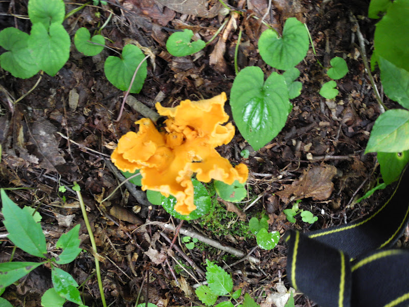
I then slogged back up to return to the trail. I met another phosphorescent fungus or moss along the way.
The trail continued its ascent, sometimes steeply, and finally I reached the ridge where a short trail leads off right to Bear Church Rock (1.2 miles from trail start), one of the lovely vistas I've encountered in SNP.
As you can see, the day was grey and the ridge was swathed in clouds. The next few miles of ridge walking would have been great except for the lack of visibility. There were many scenic turnouts (some with campsites) and from the trail itself there might have been great views to both sides (at least in winter). Eventually, the ridge flattened and widened. I met many toads who were out wandering in the post-deluge damp forest floor. Here's one of them. My newly repaired camera seems to be having problems with zooming.
There were some wildflowers and blackberries but nothing close to early abundance.
I also so more brightly colored funghi!
After many false summits I finally reached the (unimpressive) high point (3482') and then began to drop down, mostly gradually, to the junction with Cat Rocks Trail and then The Sag. I had intended at that point to add a small circuit hike down the Fork Mt. trail to the Laurel Prong Trail up the Cat Rocks Trail and repeat the bit back to The Sag but it was getting late and I didn't have much oomph. Later on I was glad I'd made this decision. So I just walked back to the car via the Fork Mt. Fire Rd. (0.8 mi.) to the Staunton River Trail and down.
Along the fire road there were scads of butterflies. The bright orange ones and pale yellow ones didn't stand still long enough to be photographed but the swallowtails did. The Joe Pye weed seemed to be their biggest attraction
The Staunton Rive Trail right from its western terminus is a delight. The sound of the many cascades accompanied me all the way down.
I noticed that the leaves are already starting to turn in significant numbers.
And I saw another flamboyant fungus.
Although the trail was well maintained, I had to watch my step descending. Lots of rocks and stinging nettles forced me to pick my steps.
When I reached the junction with the McCaskill Hollow Trail, I hiked out and back to the Jones Mt. Trail (1/2 mile each way). It was a stairstep kind of trail which ascended but never too steeply. I guess this trail is used to make circuit hikes but it seemed a bit superfluous to me since it doesn't save much mileage compared to just using the Jones Mt. Trail. In the woods I spied a discarded pillow but didn't have a trash bag with me to lug it out. I need to remember to bring spare trash bags in the future.
I had been looking at lovely pools all along the Staunton River as I walked and finally spied one big enough to take a dip in that had a trail leading to it. After a quick dip I felt much better.
After cooling off, I hustled back on the trail. At around 4:15 the skies got quite dark. At first I wondered if it was just because the sun was going behind the ridge to the west but then I felt a few drops of rain. I hurried back to the car, stopping for a short while to converse with a guy who had come to fish but was disappointed that he couldn't drive his car up the Graves Mill Trail.
As I was leaving the drops became more frequent and by the time I was back on Route 230 the rain had started in earnest eventually becoming a deluge by Warrenton.
Total for the day (from Trail Guide): 14.3; new side trail miles: 10.6; new trails: 4
I discovered some problems with my Excel table (yet again). The Jones Mt. trail wasn't there so I added it. As of today (with these new numbers) I have completed 50% of side trail miles and 48% of side trails.