Total Pageviews

Monday, February 25, 2013

Compton Peak to Hogwallow Gap

After reading February's Potomac Appalachian, Artuna and I wanted to hike up to the columnar basalt deposit off the top of Compton Peak.  Just by chance, I needed to hike that section of the AT so it worked out well.  The trail up from the parking lot in Compton Gap is a steady uphill.  In the middle section we hit a fair amount of ice in the trail and there were patches of mud, but it wasn't bad footing.  Once reaching the top, we first went down to the columnar basalt formations, which are a good distance downhill to the east. 


Then we hiked up and over to the viewpoint.  It was a cold but sunny day. 


At that point, Artuna graciously offered to return to the car and pick me up at the next road crossing.  See he went north and I went south on the AT.  En route I met John Hedrick, President of PATC, doing trailwork with another maintainer and his son, around 9 years old.  There were lots of trees down between Jenkins Gap and Hogwallow Gap.  Thanks to trail maintainers like them, hikers have an easy time on SNP trails. 

I reached Hogwallow Gap in good time and hiked back to Hogwallow Flats Overlook where Artuna was waiting.  He had paid a visit to Windham Rocks.

One additional trail and 2 at sections added. 

Thursday, February 21, 2013

AT bits plus Crusher Ridge

Last week I couldn't hike due to a trip to visit my dad in Florida and other demands.

Yesterday I hiked in Central District (at last Skyline Drive opened up!).  Several chunks of the AT plus the wonderful Crusher Ridge Trail.  It was a sunny cold day (well below freezing at 9 AM) with a steady wind blowing.  The trails were a combination of bare dirt, crusty snow, and patches of ice where prior footsteps had filled in with water and frozen.  Some parts of the trail were a bit treacherous but it was mostly good walking. 


I got an early start at Jewell Hollow Overlook and hiked north on the AT, stopping for a pitstop at the very nice Byrd's Nest 3 facility. Then hiked on ostensibly as far as Meadow Spring Trail.  I'm not sure how I did it, but I missed the trail junction.  A short while later I said, "wow, that looks like Mary's Rock ... that must be a common geological formation along here."  Wrong.  There's only one Mary's Rock.  I didn't believe it until I saw the post marking the side trail to Mary's Rock. 


Trail between Meadow Spring and Mary's Rock frozen solid


The trail was really icy, especially on the section I didn't need to hike (natch!).  Because I was pressed for time, I didn't go out to the rock but the views to the west were plenty spectacular anyway.

I stopped briefly at the Byrd's Nest 3 hut to sign the log book and skedaddle.


Then I drove down to the parking lot for Corbin Cabin Cutoff and hiked south on the AT to the Crusher Ridge Trail.  There was a fair amount of snow on the AT at this point (its being in the shade and on the western side of the ridge) but once I hit the Crusher Ridge Trail, there was little snow.  While the leaves were icy, there were no traction problems.  The Crusher Ridge Trail was a pleasant surprise.  It gently descends into the valley with lots of views west to a lovely lake (Lake Arrowhead Park?) and farms.

Tulip Tree Cabin
When I got to the SNP boundary there was a sign for the Tulip Tree Cabin.  I was curious about the cabin because I'd read in the Potomac Appalachian that is was built in a traditional design using traditional tools (by traditional volunteers) so I walked the 0.3 miles over to check it out.  It is, in fact, a lovely 2-room cabin with an outdoor fireplace and picnic table.  Nearby the cabin were a few discards that might have been used in construction.


After rejoining the trail, I sauntered back up the trail which is never steep because it used to be a road.
When I returned to the car, I had just a little bit of time left so I filled in another short blank in my AT sections.  I parked at Stony Man parking lot and hiked through the Skyland Complex down to the stables and back.

At this point in my SNAP 500 quest I have no loops left.  Every time I hike a trail or section, I have to hike back and forth, except for one 17 mile section of AT for which I'll do a car shuttle with a hiking partner. 

I discovered an error in my mileage due to a decimal point placement so my total mileage to date is only 439.  Yesterday's total mileage was 15.2 of which only 6.7 miles and one additional trail counts toward the SNAP500.

Miles CompletedTrails Completed


Friday, February 8, 2013

Fork Mountain and surrounds (Central District)

Ice lace at top of Laurel Prong Trail
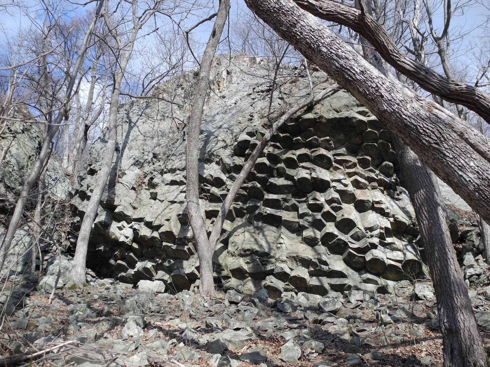
Yesterday Feb. 7 the Skyline Drive was miraculously open again so I did a hike I'd been planning for a while around Fork Mt. (the Central District Fork Mountain).  I parked at Bootens Gap and hiked north on the AT for 0.4 miles to the Laurel Prong Trail.  Toward the top of the ridge, all the tree branches had ice crystals growing on them.  It looked lovely (but I was afraid driving down that it was precipitating). 

The Laurel Fork Trail from the AT to Cat Knob Trail is a lovely one.  It slabs down gently along the hillside with beautiful winter views to the east and south.  Some neat rocks along the way too. 
Descending Laurel Prong Trail
I was worried there might be snow and ice on the trail but it turned out there were only icicles on the rocks and a thin veneer of snow at the top of the ridge.  When I got to the Cat Knob Trail I decided to ascend then rather than waiting until the end of the day to do the loop the other way around.  This turned out to be a lucky choice as you'll see later.  The trail up to Cat Knob gains altitude steadily and climbs over rocks.  Good views from various outcroppings along the way.  When I got to the top there was a small amount of snow. 
Descending from Cat Knob on Jones Mt. Tr.
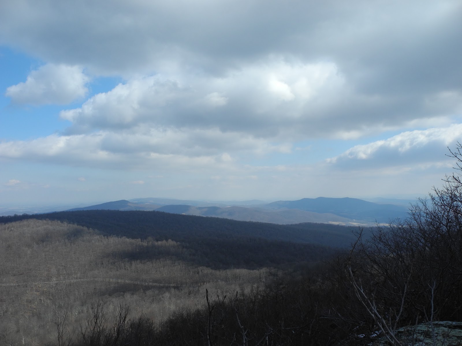
The descent from Cat Knob to The Sag took me through snow covered trail but it wasn't deep.  At The Sag I took the Fork Mt. Road up to the top of the mountain where the radar towers are.  Since it's a well-used road the going was easy.  The entire top is cluttered with installations but I was able to sneak around them to get some views to the north and west. 
Approaching top of Fork Mt.

View northwest from top of Fork Mt.
The temperature was hovering around freezing and it was quite overcast.  From time to time an anemic sun tried to burn through the clouds but there was never any direct sunlight.  As I descended from the top, it was clear that the western slopes of nearby ridges had snow on them. 
View east while descending Fork Mt. note snow on distant slope
I got back to The Sag quickly and began my trot to the very bottom of Fork Mountain Rd.  I had a bit of trouble with temperature control.  Because it was winter, there were decent views east through the leafless trees.  Unfortunately clouds and fog in the valleys made the views rather bleak.  The road is well graded and only occasionally has steep sections.  Toward the bottom of the road I was struck by a stand of young, thick trees (below) which was quite distinct from the forest elsewhere along the road.  I wondered whether this was caused by some none-to-recent clearcutting or a forest fire. 
Oddly dense woods approaching Rapidan on Fork Mt. Rd.
I got to the bottom (the Rapidan Fire Road) and saw the gorgeous Rapidan River.  Plenty of places to take dips there.  The road in look very good but open to car travel.  In fact, I saw two large SUVs drive down as I approached.  After gulping down my PB&J, I started up the road again.  I had dressed in t-shirt, long sleeve t shirt, overshirt, and wind/rain jacket plus mittens, neck gaiter, and ear warmer headband.  Going down the road I was fine but once I started ascending, I had to take the two outer layers off and remove the neck gaiter and ear warmer. 
Good swimming holes along Rapidan
The road passes over two forks of the Staunton River, both of which were full.  After passing the Staunton River Trail junction I spied a small animal scurrying up the road ahead of me.  If I didn't know better, I'd have said it was a marmot but marmots don't live around here.  I wonder if it might have been a woodchuck or a weasel (but I don't think weasels are that rotund). 
Staunton River from top of Fork Mt. Rd.
I made good time back to The Sag (third time of the day) and took the Fork Mountain TRAIL downhill from there.  It is a yellow-blazed trail which means horses can use it and it shows.  Lots of loose rocks.  I had the odd sensation as I started down that I was breaking through the crust but there was no snow.  Then I noticed ice crystals and grown under the surface of the dirt.  My breaking through was actually crushing these icy columns.  The breakthrough problem continued back on the Laurel Prong trail until it met the Cat Knob Trail again.  At the bottom of the Fork Mountain Trail is a crossing of the Laurel Prong.  Water was high and there was no way I could find to cross without getting my feet wet. Because I only had 3 miles back to the car, I decided just to wade through.  The day was getting late and the sun was definitely behind the clouds so it started getting cold.  The Laurel Prong from the Fork Mt. Trail junction goes steadily up, at first along the Laurel Prong, then it leaves the brook and ascends more steeply to the junction with the Cat Knob Trail.  I was able to stay warm (especially because of the breaking through the crust) but when I stopped to take a drink at the trail junction I got cold.  I put on my neck and head gear and started up the last mile of trail.  When I got to the ridge a cold wind was blowing (natch!) so I put back on the rest of my clothes and hustled back to the car. 

Total for the day:  15.7 miles, 4 trails completed plus another small section of the AT. 

Trails CompletedMiles Completed

Friday, February 1, 2013

Skyland-Big Meadows Loop

White Oak Upper Falls
What a surprisingly pleasant hike.  Thursday dawned quite cold and very windy but Skyline Drive was open so I decided to hike one of the routes best accessed from the Drive:  a Skyland/Fishers Gap loop using the Skyland/Big Meadows horse trail and the AT.  I'd been putting it off because I assumed hiking on the horse trail would be horrible.  I was in for a pleasant surprise.

I parked at the Limberlost Trail parking lot and hiked down the Old Rag Fire Road to where I had left off the horse trail last year.  Yes I walked all the way back and retraced my footsteps to the place where the southbound horse trail leaves the fire road.  The horse trail wasn't bad at all.  I usually think of horse trails as full of loose rocks about the size of softballs.  Yesterday the trail was filled with streams (the day before we had had torrential downpours) for much of the way but, except for a few short stretches, it was not as bad as expected.  Rapidly reaching the White Oak Canyon, I mosied down the foot trail a stretch to get a good view of the falls.  Needless to say they were full (see above).  Instead of crossing the rushing stream at the horse ford, I walked upstream to the hiker bridge and then returned to the horse trail none the wetter.  I have Melanie Perl to thank for this advice from our hike last year. 
Ford of White Oak stream (avoided by using bridge)

Water water everywhere (just off Old Rag FR)
The horse trail rolled gently along.  After crossing the White Oak it became coincident with the White Oak Fire Road (expunged from the Excel table due to overlap) which made for great walking (where there weren't pools of water).  Up and down it went.  On the east side of the ridge, when the sun shone it was a pleasant temperature for walking but I had some problems getting my clothing right.  When the sun was behind a cloud and wind blowing, I needed wind jacket zipped up, neck gaiter, and ear band.  But going uphill without wind and in the sun, that was too hot.  So I had several stops to adjust clothing.

As I said, it turned out to be a very pleasant trail for a stroll.  Because it was winter, the views east were great and Old Rag looked gorgeous.  Eventually I came to two tributaries of the Rose River.  The first ford was easy.  The second (below) gave me pause.  I was able to beat my way upstream a bit and cross over on rocks, luckily.  I then rejoined the Rose River Loop Trail, which I had hiked just a couple of weeks ago, and tramped the final 0.8 miles up to Fishers Gap.  Before I got to the gap, a nice log presented itself so I sat down to eat my sandwich and make Gatorade.  The water was just beginning to crystalize so I think the temperature was close to freezing. 
Ford of Rose River (avoided by rock hop upstream)
After that quick stop I walked over to the western side of the ridge and picked up the AT.  What a difference that small relocation made.  The wind was roaring up from the valley and it was really cold.  Back on with the winter head gear.  The AT north from Fisher's Gap has spectacular views to the west even without going out to the numerous scenic pullouts on rocky outcroppings.  The weather was clear although at around 2:15 a few flakes started falling.  Thinking this might portend Friday's predicted snow coming early, I picked up my pace.  I did take the time, however, to walk out the Rock Spring Fire Road (listed on the map but not in the book) to Skyline Drive and back.  The water on the trail was alternately solid ice and liquid, which makes me think the temp was just hovering around the freezing point.  I was worried about tree limbs falling on me as I heard creaks and groans but managed to escape unscathed.  Pollock's Knob, which I didn't remember from my thru-hike, was quite nice.

Before I knew it I had reached the Skyland Stables.  I continued on the AT until the Skyland Road then walked down to the Drive and took the Skyland Horse Trail to the Limberlost parking lot.

Total mileage for the day about 17 miles.  New miles:  16.  New or finished trails:  3.


Incredible views westward from AT

This ice chunk (1 foot in each dimension) was right in middle of trail

Ford I used of Rose River
Trails CompletedMiles Completed