I've always wanted to go some place no one has discovered yet and I finally got my wish. As it turns out, the undiscovered places are wonderful but there are downsides as you'll see later.
The Great Ring of the Sibillini (sounds like a Tolkien book, no?) is in the Appenine Range of Italy (the spine that goes straight up the center of the country) on the border between Umbria and Marche (pronounced Mar'kay) northeast of Rome. The Sibillini National Park was created quite recently (1993) and the Grande Anello (which goes by its Italian acronym, GAS) was developed to circumnavigate the park and give the hiker a taste of all its glories. As part of developing the GAS, Park officials made sure that there were "rifugios" or hostels available at daylong hiking intervals. We generally prefer to have our own bathroom so we stayed in B&B's and hotels. The official GAS is 120 km long, with several options for alternate routes and side trips. Arthur and I walked it at a leisurely pace in a week starting on June 10. Although there were still snow patches on the highest reaches of the mountains, the weather was hot and dry. I'd guess the temperature was in the 80s during the day. We started with a stay in Norcia (pronounced Norcha) which is a lovely medieval walled town and the birthplace of St. Benedict and his twin sister Scholastica. Norcia also appears to be the capital of the foodie universe, home to prime black truffle and wild boar hunting grounds and such a haven for prosciutto and salami making that many stores elsewhere are given the genus Norceria, connoting they specialize in those two products. Norcia is a short (10 km) taxi ride from Campi Vecchio where we started our hike. In many ways we chose the ideal time for our hike because the wildflowers were at peak bloom and the heat was tolerable. Yet the trail was deserted. It looked like there were a lot of people climbing Monte Vettore (the highest peak in the park) but we didn't ourselves climb it. We saw very few other hikers at all (except in the Piano Grande where people flock during wildflower season to take photos (but they mostly arrive by car))and many of the hostels, B&Bs, and restaurants were closed. As a result of the trail's being "undiscovered", the treadway wasn't beaten down in many places and we had a hard time finding places to stay and eat. In addition, often people didn't speak English (or Spanish or French) so communications required a bit of effort. These "hardships", however, gave way to a number of serendipitous occasions. The hosts at one B&B had offered to take us to town to eat at a restaurant but when we learned they were both closed they made dinner for us from their own home-canned tomatoes, wine, olive oil, and artichoke hearts. Because no taxis or buses were available when we finished, a kind man who I approached for help calling a taxi offered us a ride back to Norcia and wouldn't take any payment.
I was sorry that we hadn't allowed more time for side trips because I could easily have spent much more time enjoying the riches of the park. I used as a guide the excellent book Italy's Sibillini National Park. Walking and Trekking Guide by Gillian Price (published by the wonderful Cicerone Press in 2009) and I bought in Norcia the Parco Nazionale di Monti Sibillini carta dei sentieri (hiking map) which was far more useful than the more widely available Kompass map #666 (Monti Sibillini bike and hike map). The website for the Monti Sibillini National Park is excellent and many portions are translated into English: http://www.parks.it/parco.nazionale.monti.sibillini/Eindex.php.
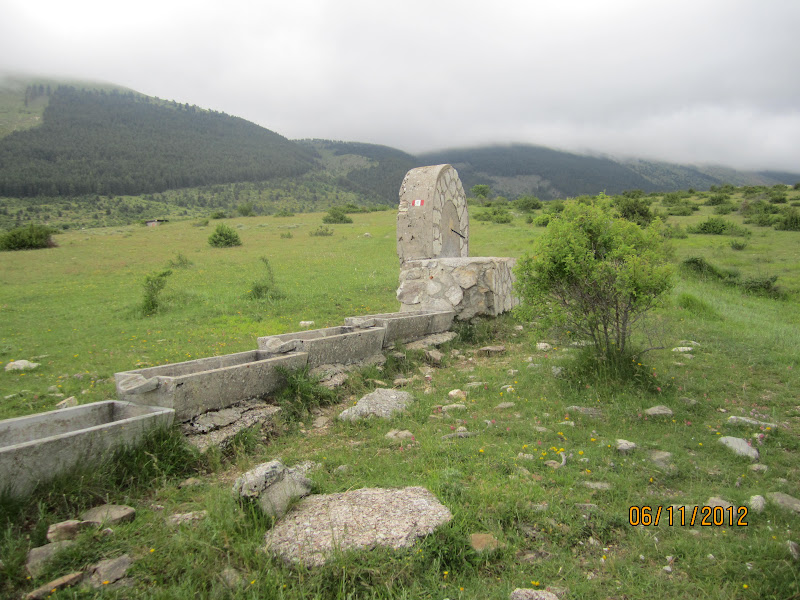
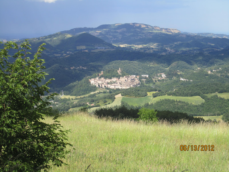
Here is a selection of the photos from the trip. We took the Castellucchio variant, which eliminated the section from Forca di Presta until the junction just before Forca de Giuda. but which added the Piano Grande (great plain) and the enchanting town of Castellucchio which occupies a hill above the Piano.
A blog describing one year of hiking all the 500 miles of trail in Shenandoah National Park.
Total Pageviews
Saturday, July 7, 2012
Tuesday, July 3, 2012
Back from the Pennine Way and Great Ring of the Sibillini
Well I'm back from my travels far and wide, including some wonderful hikes.
First, I walked the Pennine Way, Depending on which source you consult, it's either 256 (or 270) miles long. My cousin and I walked it in 18 days. It stretches from the greater Manchester, England area to just across the Scottish border. It was the first National Trail in England. The start of the trail, in Edale, was the site of a "mass trespass" on Kinder Scout which laid the groundwork for the National Parks and for the Access to the Countryside Act which allows walkers right of way on private land (virtually all the land in the UK is privately owned).
The trail is sort of well-marked (except where it isn't and where markings are most needed) and travels more or less along the ridge of the Pennine range, the backbone of England, and over the Cheviot range (pronounced Cheev'ee ot). Most of the trail is through farmland and sheep are found all along the trail. Due to some accident of geological history, the entire route is prone to swampy ground (called moors). Luckily, large stones pave the way more than half the time but they always seem to run out when you need them most. The highest point on the trail is Cross Fell, (2930') so it's not high altitude and the largest altitude gain in a day is 1100 meters (3500 feet or so).
I can't relay all the wonderful adventures we had on the trail but suffice it to say that it was a great way to see a wide variety of people, plants, geology, landscapes, and towns. Everyone had told me beforehand that it rains all the time along the Pennine Way. We had only 1/2 day of rain (and it was light). Excellent sources for the Pennine way are Pennine Way by Edward de la Billiere, Keith Carter & Chris Scott (Trailblazer Publications, 2011), the National Trail Guides (two), and the Harvey Maps (3) for the Pennine Way. The publisher of the first book has a companion website with waypoints that can be downloaded to your GPS. I found these invaluable when tromping through trail-free swamps looking for the trail.
More on the Great Ring of the Sibillini in my next posting.
First, I walked the Pennine Way, Depending on which source you consult, it's either 256 (or 270) miles long. My cousin and I walked it in 18 days. It stretches from the greater Manchester, England area to just across the Scottish border. It was the first National Trail in England. The start of the trail, in Edale, was the site of a "mass trespass" on Kinder Scout which laid the groundwork for the National Parks and for the Access to the Countryside Act which allows walkers right of way on private land (virtually all the land in the UK is privately owned).
The trail is sort of well-marked (except where it isn't and where markings are most needed) and travels more or less along the ridge of the Pennine range, the backbone of England, and over the Cheviot range (pronounced Cheev'ee ot). Most of the trail is through farmland and sheep are found all along the trail. Due to some accident of geological history, the entire route is prone to swampy ground (called moors). Luckily, large stones pave the way more than half the time but they always seem to run out when you need them most. The highest point on the trail is Cross Fell, (2930') so it's not high altitude and the largest altitude gain in a day is 1100 meters (3500 feet or so).
I can't relay all the wonderful adventures we had on the trail but suffice it to say that it was a great way to see a wide variety of people, plants, geology, landscapes, and towns. Everyone had told me beforehand that it rains all the time along the Pennine Way. We had only 1/2 day of rain (and it was light). Excellent sources for the Pennine way are Pennine Way by Edward de la Billiere, Keith Carter & Chris Scott (Trailblazer Publications, 2011), the National Trail Guides (two), and the Harvey Maps (3) for the Pennine Way. The publisher of the first book has a companion website with waypoints that can be downloaded to your GPS. I found these invaluable when tromping through trail-free swamps looking for the trail.
More on the Great Ring of the Sibillini in my next posting.
Tuesday, May 22, 2012
Pennine Way after 6 days
Greetings from Hawes England, home of Wensleydale Cheese (made famous by Wallace and Grommit). We've had 4 seasons of weather over the past 5 days and 107 miles. Very cold and windy, some snow flurries, and finally (the last two days) the sun has shown and it has gotten warm. Yesterday we climbed Pen y Ghent, which is often run up as part of the "3 peaks Challenge". We just walked up. It looked daunting but the up was easy. Coming down the far side was a long painful descent.
Sunday, May 13, 2012
A pause to refresh
I'm about to leave for an extended trip which includes hiking the Pennine Way (the oldest National Trail in UK) and the Grande Anello dei Sibillini in central Italy. The Pennine Way, like the Appalachian Trail, is the most famous and beloved (and feared) trail in Great Britain. It is 256 (or maybe 268) miles long going over the spine of the island. I'm going with my cousin Marcy and we're planning to spend 19 days on the trail and stay in B&B's and hostels along the way. The Sibillini National Park is the newest national park in Italy and the GAS is only 5 or so years old. It is 120 km long and Artuna and I will plan to walk it in 8 days staying in rifugios and b&bs. I'll try to post from the hikes but internet access is limited.
I didn't hike any SNAP trails this week because I was getting ready for my other hiking trip. Here's my current standing.
So far I have hiked a total of 209.1 miles of which 136.6 are unique side trail miles. I have completed 52 out of 173 side trails (174 total trails, when you count the AT). Here are my thermometers:
One third done!
I didn't hike any SNAP trails this week because I was getting ready for my other hiking trip. Here's my current standing.
So far I have hiked a total of 209.1 miles of which 136.6 are unique side trail miles. I have completed 52 out of 173 side trails (174 total trails, when you count the AT). Here are my thermometers:
Sunday, May 6, 2012
Out and back repeat repeat repeat. Plus ticks.
Thursday May 3 I thought I'd finish up some trails in the North district that don't connect to other trails. To minimize my driving, I decided to hike most of them from Skyline Drive which meant hiking down first then up to finish the trail. Psychologically it's harder for me but it made more sense to drive along Skyline Drive to hike the trails.
I started with the Jenkins Gap Trail which went through a recent burn section. I wonder if the "Jenkins" in the name refers to Walker Jenkins, a tenant farmer who had been promised tenancy until he died but was evicted dramatically and bodily to make way for the National Park. Many sad stories like this surround the origins of the Shenandoah National Park.
This seems to be used largely as a horse trail because there are lots of small rocks scattered throughout the trail. Although some views were still possible through the expanding leaf cover, it wasn't a particularly scenic trail. At the bottom it went along a stream but otherwise it was an unremarkable trail. Detracting further from the walk was the overgrown nature of the trail (I'm very wary of ticks, which I associate with long grass growing in the treadway) and a scattered pile of garbage near the top of the trail. Some thoughtless passerby probably just dumped their trash a short walk down the trail. I walked only as far as the park boundary where the post said 1.2 miles to the parking lot (the guidebook says 1.0 miles to the road) and the map say 1.6 miles. I'll record it as 1.2 miles.
The second trail, the Browntown Trail (ne Browntown/Harris Hollow Road) was even more overgrown than the Jenkins Gap Trail. Exotic invasive Japanese stiltgrass and garlic mustard crouched in over the treadway for long stretches.
Once again, I was unhappy and tried to avoid touching the vegetation along side the trail but it was impossible to do. I met a friend along the way who was a cute as could be:
Although the guidebook had promised Mountain Laurel in early June, half way down the trail I started to see blooms.
I also saw Squaw Root and Louse wort not quite in bloom
I found a plant I need help identifying. It looks to me like a fern.
If any readers know what that is, please illuminate me.
I hiked the Browntown Trail as far as the Park Boundary (2.3 miles each way by the guidebook and guidepost). By this time the day was getting quite hot and the leaves do not yet quite provide full shade, at least up on the ridge. So en route to the next trail, I stopped at Elkwallow Wayside (which had just opened for the summer) to get a cold soda. A small group of thru hikers was entertaining the tourists at a couple of picnic tables.
Next up, the Rocky Branch Trail, another trail used largely by horses, I suspect. True to its name, it was pretty rocky. As far as I'm concerned it had no redeeming hiking value even though it might make a good horse trail. I parked at the Pass Mountain Overlook and walked back along Skyline Drive to the trail, first descending as far as the Park boundary (0.8 mile each way) and returning, then along the trail as far as the Hull School Trail. Little shade, lots of rocks in the footpath, and no wildflowers. After it crosses the A.T., the trail goes through an open field (in the blaring sun) where I saw some huge black birds surfing the air currents. I think they might have been red headed vultures. Once I finished the trail (another 2 miles) I decided I'd prefer to walk back to my car along Skyline Drive. You know it's a bad trail when walking on Skyline Drive is appealing.
Once I got back to the car, I did a turn around the so-called Pass Mountain Stroller Trail (a wheeled stroller would be unhappy with the stairs and the woodchips). Just after I started the trail, I saw a juvenile bear who seemed scared by me. I got out my camera and tried to quietly continue along the trail but the bear kept stopping, seeing me again, and crashing further away in the woods. I never got a good shot of him. Nice view from the overlook, though.
I had, I thought, saved the best for last. I left the park at Thornton Gap and drove back along 522 toward Front Royal so I could hike the Jordan River Trail. Since it was such a hot day and I had been hiking up and down the ridge all day, I was really looking forward to a dip in the Jordan River. Not so fast, Judo. It was a bit difficult to find the start of the trail, which is on private land and unsigned. The map and book together didn't make it clear exactly where to go but eventually I found the trail. Much to my dismay, the trail does not go close to the Jordan River within park boundaries and even then it doesn't have any good pools for dunking. Luckily though, the Jordan River Trail was a delight to hike and I saw several wildflowers. Mostly the Showy Orchids were out all around the trail
Plus the mayapples were in bloom.
Another plant identification needed. Unfortunately this is not a good picture but is has a long drooping trumpet. By the end of the day, I had completed 5 new trails, 15.4 miles of which only 6.8 are unique sidetrail miles. For all my care in where I stepped and use of Deet and a tick check after I got home, I discovered a tick on my toe the next morning. It's going to be a long summer.
I started with the Jenkins Gap Trail which went through a recent burn section. I wonder if the "Jenkins" in the name refers to Walker Jenkins, a tenant farmer who had been promised tenancy until he died but was evicted dramatically and bodily to make way for the National Park. Many sad stories like this surround the origins of the Shenandoah National Park.
This seems to be used largely as a horse trail because there are lots of small rocks scattered throughout the trail. Although some views were still possible through the expanding leaf cover, it wasn't a particularly scenic trail. At the bottom it went along a stream but otherwise it was an unremarkable trail. Detracting further from the walk was the overgrown nature of the trail (I'm very wary of ticks, which I associate with long grass growing in the treadway) and a scattered pile of garbage near the top of the trail. Some thoughtless passerby probably just dumped their trash a short walk down the trail. I walked only as far as the park boundary where the post said 1.2 miles to the parking lot (the guidebook says 1.0 miles to the road) and the map say 1.6 miles. I'll record it as 1.2 miles.
The second trail, the Browntown Trail (ne Browntown/Harris Hollow Road) was even more overgrown than the Jenkins Gap Trail. Exotic invasive Japanese stiltgrass and garlic mustard crouched in over the treadway for long stretches.
Once again, I was unhappy and tried to avoid touching the vegetation along side the trail but it was impossible to do. I met a friend along the way who was a cute as could be:
Although the guidebook had promised Mountain Laurel in early June, half way down the trail I started to see blooms.
I also saw Squaw Root and Louse wort not quite in bloom
I found a plant I need help identifying. It looks to me like a fern.
If any readers know what that is, please illuminate me.
I hiked the Browntown Trail as far as the Park Boundary (2.3 miles each way by the guidebook and guidepost). By this time the day was getting quite hot and the leaves do not yet quite provide full shade, at least up on the ridge. So en route to the next trail, I stopped at Elkwallow Wayside (which had just opened for the summer) to get a cold soda. A small group of thru hikers was entertaining the tourists at a couple of picnic tables.
Next up, the Rocky Branch Trail, another trail used largely by horses, I suspect. True to its name, it was pretty rocky. As far as I'm concerned it had no redeeming hiking value even though it might make a good horse trail. I parked at the Pass Mountain Overlook and walked back along Skyline Drive to the trail, first descending as far as the Park boundary (0.8 mile each way) and returning, then along the trail as far as the Hull School Trail. Little shade, lots of rocks in the footpath, and no wildflowers. After it crosses the A.T., the trail goes through an open field (in the blaring sun) where I saw some huge black birds surfing the air currents. I think they might have been red headed vultures. Once I finished the trail (another 2 miles) I decided I'd prefer to walk back to my car along Skyline Drive. You know it's a bad trail when walking on Skyline Drive is appealing.
Once I got back to the car, I did a turn around the so-called Pass Mountain Stroller Trail (a wheeled stroller would be unhappy with the stairs and the woodchips). Just after I started the trail, I saw a juvenile bear who seemed scared by me. I got out my camera and tried to quietly continue along the trail but the bear kept stopping, seeing me again, and crashing further away in the woods. I never got a good shot of him. Nice view from the overlook, though.
| View from start of Pass Mt. "stroller" trail |
| Showy Orchid (Orchis spectabilis) |
| Mayapple bloom |
| Name this plant! |
Wednesday, May 2, 2012
Wild about Wild
Just for a change of pace, I thought I'd write a book review of Wild. From Lost to Found on the Pacific Crest Trail.
Unlike most authors recounting long distance hikes, Cheryl Strayed is an exceptional storyteller. Wild is about her 1000-mile hike along or near the Pacific Crest Trail but the physical trail is really just the backdrop for her personal history, a wonderful cast of colorful characters, and the author's physical and emotional growth along the trail. She hikes the trail to recover from her mother's premature death, her own relationship and chemical problems, and from a rudderless existence. She was a complete novice backpacker when she started, with simultaneously inadequate and excessive gear, wilderness ignorance, and a naivete about the PCT. That she survived is truly amazing, especially given the extreme climates she walked through and several major mistakes she made (like not carrying enough water through the desert and throwing away her ice-ax before she was finished with the snowy sections).
The story skillfully interweaves her family life before her mother died with her adult life story, her hike, and the people she met along the way. She grew up with domestic abuse, poverty, a "back to the land" existence in rural Minnesota, a father who abandoned the family and a stepfather who made it whole (at least until Cheryl's mother died). Her adult life spanned going to college in tandem with her mother's attending the same college, marriage at 19 to a wonderful man, the family's dissolution after her mother's death, serial extramarital affairs, heroin use, and many dead end jobs. Very few people with that kind of background end up doing long-distance hiking much less persevering (as the author did) for1000 miles with footwear that ravage one's feet and a grossly overweight backpack. She did get geographically lost many times but her lostness was far more emotional than physical. She found her way back to the trail after many detours but more importantly she found inner strength, natural beauty, and uncommon human goodness among strangers. Even on the single occasion when she met a bad guy who seemed to have rape in mind she escaped without harm. She is one lucky woman.
Most books by long distance hikers wear down the reader with day by day, blow by blow descriptions of the trail and/or of hiking gear. Not this one. Wild had just the right mix of trail days, Strayed's personal history, and off-trail experiences. And yet so many of her stories resonated with me about long-distance hiking. I loved her analogy of long distance hiking as being like knitting a sweater: You knit it going uphill and then you unravel it going down and then repeat the process over and over and over.
The characters she met at camps near the trail, in towns, and hitchhiking come alive for the reader because the author portrays them in three dimensions. Strayed has a gift for timing as well. The suspense builds in each trail section. Will she reach the water in time? Will her money hold out? Will she find the trail? Will her resupply box be there? The author describes in depth just the right number of specific events to enhance reader's understanding of what she went through. Some experiences illustrate the nature of trail life. Her obsession with Snapple Lemonade is just one example. Other vignettes serve to illuminate the author's own history and personality. At one point, she was down to two cents but she used that experience to reflect that her history of poverty had given her the ingenuity and a kind of fearlessness to keep going. And some stories are there simply to enable us to appreciate the beauty of the Pacific Crest Trail.
The year after Bill Bryson's book about walking the Appalachian Trail (A.T.) hit the bestseller list, there was a huge increase in people starting the A.T. As you would expect, a large proportion of them dropped out along the way. If A Walk in the Woods is any gauge, folks who work on and around the PCT better brace themselves for the onslaught because this book is going to send thousands of completely unprepared hikers onto the trail next year. For better or worse, the Pacific Crest Trail is dramatically different from the A.T. and far less forgiving so there will probably be an increase in rescues and deaths on the PCT as well.
That Strayed was not a "thru hiker" made Wild a better adventure. She could skip over difficult sections, change her endpoint, and take time off without becoming obsessed about covering every mile of the trail or getting through high mountains before the snows started. It also absolves her of accusations of cheating by the self-appointed arbiters of thru-hike sanctity (Bill Bryson is still reviled by many thru hikers on the A.T. because he didn't really hike the trail.).
Because Cheryl Strayed was an inexperienced woman walking alone on a very demanding trail, I think this book will appeal particularly to women but anyone who dreams of getting away from it all would enjoy it and learn that determination trumps equipment, physical fitness, and experience... at least if you're lucky. .
Unlike most authors recounting long distance hikes, Cheryl Strayed is an exceptional storyteller. Wild is about her 1000-mile hike along or near the Pacific Crest Trail but the physical trail is really just the backdrop for her personal history, a wonderful cast of colorful characters, and the author's physical and emotional growth along the trail. She hikes the trail to recover from her mother's premature death, her own relationship and chemical problems, and from a rudderless existence. She was a complete novice backpacker when she started, with simultaneously inadequate and excessive gear, wilderness ignorance, and a naivete about the PCT. That she survived is truly amazing, especially given the extreme climates she walked through and several major mistakes she made (like not carrying enough water through the desert and throwing away her ice-ax before she was finished with the snowy sections).
The story skillfully interweaves her family life before her mother died with her adult life story, her hike, and the people she met along the way. She grew up with domestic abuse, poverty, a "back to the land" existence in rural Minnesota, a father who abandoned the family and a stepfather who made it whole (at least until Cheryl's mother died). Her adult life spanned going to college in tandem with her mother's attending the same college, marriage at 19 to a wonderful man, the family's dissolution after her mother's death, serial extramarital affairs, heroin use, and many dead end jobs. Very few people with that kind of background end up doing long-distance hiking much less persevering (as the author did) for1000 miles with footwear that ravage one's feet and a grossly overweight backpack. She did get geographically lost many times but her lostness was far more emotional than physical. She found her way back to the trail after many detours but more importantly she found inner strength, natural beauty, and uncommon human goodness among strangers. Even on the single occasion when she met a bad guy who seemed to have rape in mind she escaped without harm. She is one lucky woman.
Most books by long distance hikers wear down the reader with day by day, blow by blow descriptions of the trail and/or of hiking gear. Not this one. Wild had just the right mix of trail days, Strayed's personal history, and off-trail experiences. And yet so many of her stories resonated with me about long-distance hiking. I loved her analogy of long distance hiking as being like knitting a sweater: You knit it going uphill and then you unravel it going down and then repeat the process over and over and over.
The characters she met at camps near the trail, in towns, and hitchhiking come alive for the reader because the author portrays them in three dimensions. Strayed has a gift for timing as well. The suspense builds in each trail section. Will she reach the water in time? Will her money hold out? Will she find the trail? Will her resupply box be there? The author describes in depth just the right number of specific events to enhance reader's understanding of what she went through. Some experiences illustrate the nature of trail life. Her obsession with Snapple Lemonade is just one example. Other vignettes serve to illuminate the author's own history and personality. At one point, she was down to two cents but she used that experience to reflect that her history of poverty had given her the ingenuity and a kind of fearlessness to keep going. And some stories are there simply to enable us to appreciate the beauty of the Pacific Crest Trail.
The year after Bill Bryson's book about walking the Appalachian Trail (A.T.) hit the bestseller list, there was a huge increase in people starting the A.T. As you would expect, a large proportion of them dropped out along the way. If A Walk in the Woods is any gauge, folks who work on and around the PCT better brace themselves for the onslaught because this book is going to send thousands of completely unprepared hikers onto the trail next year. For better or worse, the Pacific Crest Trail is dramatically different from the A.T. and far less forgiving so there will probably be an increase in rescues and deaths on the PCT as well.
That Strayed was not a "thru hiker" made Wild a better adventure. She could skip over difficult sections, change her endpoint, and take time off without becoming obsessed about covering every mile of the trail or getting through high mountains before the snows started. It also absolves her of accusations of cheating by the self-appointed arbiters of thru-hike sanctity (Bill Bryson is still reviled by many thru hikers on the A.T. because he didn't really hike the trail.).
Because Cheryl Strayed was an inexperienced woman walking alone on a very demanding trail, I think this book will appeal particularly to women but anyone who dreams of getting away from it all would enjoy it and learn that determination trumps equipment, physical fitness, and experience... at least if you're lucky. .
Subscribe to:
Posts (Atom)